From Smart Cities and Connected Vehicles: Commercial Satellite Imaging Augments It All
by Himanshu Joshi
Pune, India, May 3, 2021--Commercial satellite imaging provides images of the Earth captured by satellites operated by private companies and governments around the world. Commonly used satellite imaging spacecraft that are operated by private companies and governments include WorldView-2, WorldView-3, IKONOS, GeoEye-1, and various others. Before 1972, satellites were only used for military operations and satellite imagery was commercialized in 1984. IKONOS became the first high-resolution commercial imaging satellite that was launched in September 1999.
Companies sell this imagery to big corporations, for example, Google Maps and Apple Maps, and governments by providing authorizing agreements. Today, satellite imagery has become widely available, owing to the advent of inexpensive and easy-to-use software that offers easy access to satellite imagery provided by several companies active in the satellite imagery industry. Satellite images are used for various applications such as mapping of constructional projects, border surveillance, security of energy resources, and environment monitoring & management. Moreover, commercial satellite imaging is a critical part of location-based services (LBS) and is very useful in offering useful insights for emergency response in incidents such as natural disasters and life-threatening events. The activities, changes, and trends can be spotted, observed, and examined more proficiently with satellite imagery, which benefits the people and environment.
Satellite image database offers access to inexpensive satellite imagery. While some of the data is available publicly, the commercial satellite data players sell satellite images and data or they can be ordered to deliver a constant supply of data from a particular area. One of the most important properties of any satellite imagery is its spatial resolution. The competition among the companies to improve spatial resolution is attaining impetus across the world. Basically, spatial resolution is the smallest gap among two entities that can be picked out in a given image.
The preferred spatial image resolution is determined by considering the final objective for conducting primary satellite imaging, and on the size of the observed area. Spatial resolution not only represents the ability to detect the presence of two entities but also their features in remote sensing technology. Analogous to digital photography, greater resolution indicates improved visibility of fine points represented on the image.
Market Size
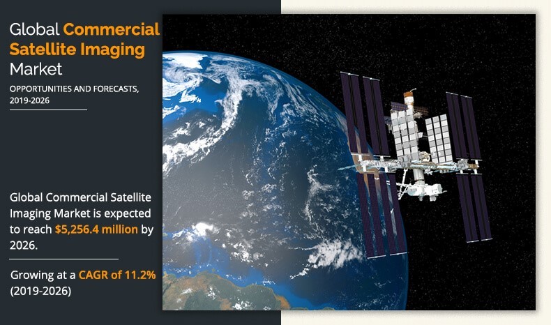 The global commercial satellite imaging market was valued at US$ 2.24 Billion in 2018, and is expected to reach US$ 5.25 Billion by 2026, registering a CAGR of 11.2% from 2019 to 2026. Utilizing these images for commercial purposes is knows as commercial satellite imaging, which includes various applications such as environment monitoring & management, security of energy resources, surveillance of border areas, and mapping of constructional projects. The images captured with the help of satellite are used in commercial applications such as. One of the key advantages of satellite imaging is faster image delivery, which provides comprehensive earth coverage, thus making commercial satellite imaging service a preferred choice over other imaging services.
The growth of the global commercial satellite imaging market is anticipated to be driven by increase in dependence on location-based services (LBS). This is attributed to the fact that location-based services play an important role by providing real-time geographical data with the use of smart devices. In addition, commercial satellite imaging is applicable across various sectors, including defense, construction, transportation, and others, which acts as a key driver of the global commercial satellite imaging market.
Some of the key players operating in the commercial satellite imaging sector are Maxar Technologies, Planet Labs Inc., Satellite Imaging Corporation, L3Harris Technologies, Inc., ImageSat International N.V., and Ursa Space Systems Inc. In recent years, the commercial satellite data market has witnessed several developments in the forms of partnerships, product developments, and others, which indicate robust growth of the market and denotes steady growth in the future. For instance, in October 2018, NASA awarded a sole-source contract for high-definition commercial synthetic aperture radar (SAR) and electro-optical satellite imagery to DigitalGlobe, a Maxar Technologies company.
In April 2018, Iceye, a Finnish microsatellite manufacturer signed a partnership deal with Ursa Space Systems, a company that provides commercial insights from geospatial data. In February 2020, L3Harris Technologies entered into a partnership with the Air Force Life Cycle Management Centre to develop software to allow analysts to apply artificial intelligence (AI) to find entities in huge datasets in a simple and easy way, thereby addressing the critical defense requirement for automation to evaluate big geospatial datasets. In October 2020, European Space Imaging signed a collaboration agreement with Satellogic, a company active in the geospatial analytics and satellite imagery industry to considerably enhance the tasking abilities along with introducing hyperspectral images to customers.
Factors, such as the rising adoption of artificial intelligence (AI), machine learning (ML), and cloud computing in the space sector, are expected to boost the growth of the commercial space imaging market over the years. For instance, in June 2019, Lockheed Martin launched an AI-based satellite image identification platform known as the Global Automated Target Recognition (GATR), which makes use of open-source deep learning libraries to detect and categorize large datasets quickly and efficiently. Moreover, the rising use of satellite data in the development of smart cities and connected vehicles is anticipated to offer lucrative growth for the commercial satellite imaging market in the coming years. For instance, in April 2019, Maxar Technologies Inc. entered into a partnership with Toyota Research Institute-Advanced Development, Inc. (TRI-AD) and a leading IT services provider NTT DATA Corporation to create an automated HD map of the Tokyo metropolitan region for autonomous vehicles using high-resolution satellite imagery data.
Impact of COVID-19
The COVID-19 crisis resulted in adverse economic scenarios in the market globally. The measures to contain the spread of the virus resulted in massive disruption in supply chains, declining business revenues, and increased panic among customers. Governments of different nations declared strict lockdowns and temporary shutdown of industries that affected the overall production and sales across all sectors. The commercial satellite imaging market also experienced decline in revenues in 2020 due to the COVID-19 crisis. International lockdowns impacted the design, development, and manufacturing activities of companies active in the commercial satellite imaging market. Struggling global markets with a large focus on tackling the adverse economic scenarios, owing to the pandemic are also expected to negatively impact the demand for a significant number of years.
The COVID-19 pandemic forced several nations to re-plan the launch of satellite missions and strategize their operations, for instance, signing partnership deals with private players. The pandemic led to the delay of satellite missions planned for the launch in 2020. For instance, the Indian Space Research Organization (ISRO) delayed the lift-off of the Gisat-1 satellite due to the countrywide lockdown imposed to check the spread of the virus. Moreover, the Department of Space (DoS) signed a deal with the Indian rocket company Agnikul Cosmos Pvt. Ltd in December 2020 to access technical expertise and facilities existing in ISRO offices to proceed with their rocket development program. Moreover, in response to the COVID-19 pandemic, the U.S. delayed the launch of GPS-3 in 2020 to minimize potential exposure of coronavirus to personnel. With the initiation of vaccination across the globe, the COVID-19 pandemic is anticipated to vanish gradually over the years while the space sector is expected to attain a considerable leap in the near future.
According to a recent report published by Allied Market Research, titled, Commercial Satellite Imaging Market gives detailed analysis of the pandemic on the market. This includes the current impact on the revenue, sales, and new measures taken by players, among others. You can request a sample of the report here: https://www.alliedmarketresearch.com/request-sample/1751
------------------------------
 Himanshu Joshi works as a Research Associate at Allied Market Research. Himanshu conceptualizes and implements a scalable business strategy and provides strategic leadership to the clients. His forte lies in deep research, market analysis, customer assessment, and sustainable market strategy, among others. For more information on research on the Commerical Satellite Imagery Market go to:
https://www.alliedmarketresearch.com/commercial-satellite-imaging-market