Trends in the Geospatial Market
By Elisabeth Tweedie
Los Angeles, Calif., May 12, 2025 - Investment in geospatial technologies continues to grow at a rapid pace. According to NovaSpace, an estimated 5,401 earth observation satellites will be launched between 2024 and 2033. This is a 190% increase from the 1,864 satellites launched in the previous decade. This growth is being fueled by technological innovation and increased demand. As climate change, migration, urbanization and conflicts increase, the need for timely and precise geospatial information continues to grow.
There are essentially two parts to geospatial services: the upstream segment, comprised of the satellites, drones and aircraft which capture and transmit images and data; and the downstream segment comprised of companies that provide the resources to analyze and interpret all that data, converting it into timely, actionable, information and insights.
This downstream part is as important, if not more important, than the collection of data. Overlaying various data layers, enables insights into the relationship between multiple environmental factors. An example would be overlaying data on soil type, vegetation cover, rainfall pattern and population density to understand how human activity impacts ecosystems. Spatial analysis is used to identify patterns, predict changes and assess the impact of any deliberate interventions – changing land use for example. Being able to combine and present all this information in clear visual maps or 3D models, greatly enhances our understanding of the environment, situations and factors impacting change.
Key Components of Geospatial Technologies
- Remote Sensing. The collection of data about the Earth’s surface using instruments mounted on satellites, drones and aircraft. This is a key component in detecting changes in land cover and assessing environmental changes.
- Global positioning systems (GPS), that pinpoint precise locations on the Earth’s surface for mapping, navigation and tracking.
- Telemetry, of course is essential for communicating the data collected back to a central source.
- Geographical information systems (GIS), software systems that capture, store, analyze and display spatial data. GIS allows users to create and analyze multi-layer maps. For example, a map may show soil type, vegetation, crops and settlements.
- Thematic mapping, unlike conventional maps that may show country and/or regional boundaries, thematic maps, show the distribution of various elements within those divisions: population, prevalence of a particular illness, percent of urbanization for example.
 |
|
These components work in tandem, the first two are responsible for data collection and location. GIS are the workhorses that store and analyze the data to turn it into information. A herculean task given the volume of data that is being captured every day. Legacy systems that aren’t employing artificial intelligence (AI) and machine learning (ML) are labor intensive and time consuming to operate. In addition, given the enormous size of geospatial databases, for legacy systems that are not stored in a Cloud, whether public or private, bandwidth issues can cause delays, when up or downloading data or updates. As well as minimizing delays, data that is stored and processed in a Cloud can be accessed from anywhere, on demand.
Fortunately, Machine Learning (ML) and Artificial Intelligence (AI) are now being adopted by the leading players in geospatial technologies. For example, ML algorithms are being used to facilitate automatic feature extraction and pattern recognition in spatial analysis, facilitating classification, and predictive modeling. Outlier detection can improve quality control by identifying overlapping or missing attributes, which significantly reduces the time needed for manual reviews. AI can identify changes in land use by comparing satellite images over time, and it can also build 3D models of the terrain and structures.
While these tools play a major role in reducing workloads, streamlining operations and, most importantly, improving the quality of information that can be derived from the raw data, they do not eliminate the need for human oversight, local and domain experts, still play a very significant role in geospatial technologies.
Thematic mapping is a user-friendly way of showing the results of the analysis.
Earth Observation Satellites– Sensors
The type of data captured by an Earth Observation (EO) satellite depends very much on the type of onboard sensor. The main sensors are:
- Optical: These capture visible and near-infrared light, so are ideal for vegetation analysis and land use monitoring. However, since these rely on reflected sunlight, they cannot be used at night time or when there is cloud cover.
- Thermal Infrared Sensors: These are able to detect heat emitted from the earth’s surface, so are able to be used at night as long as there is no cloud cover. Key uses are to monitor land and sea temperatures, volcanoes, wildfires, etc.
- Synthetic Aperture Radar (SAR) Sensors: These emit microwaves to capture the condition of the earth’s surface by the intensity and phase of the reflected wave. Since microwaves can pass through clouds, these can be used at any time of day regardless of weather conditions. These are often used for topographic mapping, identifying changes due to earthquakes, deforestation and ship movements for example. SAR is also very important for military applications.
- Light Detection and Ranging (Lidar): This utilizes laser pulses to determine the precise height of an object, by measuring the time it takes for the pulse to reflect back from the object and the strength of the return pulse. Its primary use is for ocean topography, vegetation density and height, wind speed and thickness of an ice-sheet.
- Microwave Radiometers measure microwaves naturally emitted from the earth, so they are functional 24/7 regardless of weather conditions. These are primarily used for measurement of sea temperature, atmospheric conditions, distribution of sea ice and snow cover thickness, etc.
Applications
Geospatial technology is no longer a niche segment. In fact, it would be hard to overstate, just how important it is. It is an indispensable tool for decision making in many key areas of life.
In the report “Geospatial Knowledge Infrastructure” jointly published by Geospatial World and the United Nations Statistics Division in 2022, it was estimated that by 2030 the global economic impact of the adoption of geospatial technology across multiple verticals, will be in the range US$15.84-30.24 trillion, a significant increase from the US$2.2-5.4 trillion that was estimated for 2022.
Key applications include:
- Disaster Response: Tracking wildfires, Identifying the extent of flooding, Identifying the extent of earthquake damage.
- In all these cases, mapping escape routes and revealing the extent of damage, helps first responders reach the area and assess what resources are needed for rescue efforts and damage mitigation. This vital information, helps with damage containment and can be an aid to minimizing injury and loss of life.
- Tracking wildlife – GPS devices attached to animals, provide insights into migration routes and habitat usage, enabling effective wildlife management and conservation planning.
- Monitoring deforestation, remote sensing enables tracking of deforestation and helps understand the impacts of this loss and identify areas at risk.
- Assessing water quality. GIS can map water pollution sources, analyze water flow patterns and monitor the health of aquatic ecosystems.
- Climate Change. GIS can contribute to the understanding of the impact of climate change, by monitoring changes in sea level, ice melt, and vegetation, for example.
- Identifying major sources of carbon dioxide and methane.
- Supporting sustainable agriculture. GIS and remote sensing help farmers optimize irrigation, monitor crop health and manage land use.
- Urban Planning, monitoring traffic flow, and mapping green spaces for example, aid with resource allocation and help create sustainable urban environments.
- Border control.
- Geospatial tools are also invaluable for modern warfare, providing troops on the ground with information about the enemies’ locations and movements, as well as clearly showing the destruction on the ground as a result of enemy action. In particular, the use of synthetic aperture radar (SAR) which is able to “see” in the dark and through heavy cloud cover, provides a level of detail not previously available.
Looking to the Future Technology
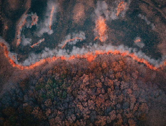 |
Photo courtesy of NSG |
Also on the supply side, miniaturization is having a major impact, allowing earth observation satellites to carry more instruments and more powerful instruments. These include Very High Resolution (VHR) and Very Very High Resolution (VVHR) cameras, Multispectral and Hyperspectral sensors. Sensors to measure greenhouse gases, and Radio Frequency (RF) and metocean sensors.
Naturally, the higher the resolution the better the image. Multispectral and hyperspectral add another dimension. These sensors capture data in multiple spectral bands, which aid in analysis. Multispectral is limited to specific spectral bands, anywhere from a few to a few dozen. Hyperspectral is more advanced, it can capture thousands of spectral bands to provide a very detailed look at the features being observed. Both of these are rapidly becoming vital tools in GIS providing a wealth of additional information, enhancing our understanding of what is being monitored or observed.
Multispectral sensors capture data more frequently than hyperspectral sensors which facilitates regular monitoring of an area. Due to the complexity of processing hyperspectral data, these sensors capture data less frequently and the results have lower spatial resolution.
Both have advantages, that make them suitable for different applications. Multispectral imagery is well suited to land use applications. For example, it is key for crop health checks in agriculture and for helping find weeds, diseases and even pests. It is also used to identify different land usage for land mapping, which makes it key for environmental tracking and urban planning. Similarly, it is an aid. for forestry management.
Hyperspectral imagery on the other hand, is key for geological mapping, mineral exploration for example. The sensors can identify tiny changes in the earth’s surface that are key to finding certain minerals. It also helps fight pollution as it can identify pollutants like oil spills. Hyperspectral sensors can also identify and map temperature differences. This information is helpful in planning cooler, greener cities.
Being able to identify and monitor carbon and methane emissions is a vital tool to help identify major sources of greenhouse gasses (carbon dioxide and methane) and in fighting climate change.
Data extraction and information processing, aided by ML and AI, are leading to new ways of presenting the results, including displaying the 3D models in virtual reality. This can be particularly useful for the defense market and also for modeling autonomous driving.
There is an increasing trend for Internet of Things (IoT) data to be integrated with geospatial data. This adds another facet to the value that can be derived. For example IoT sensors will show the current location of shipping containers that they are attached to. Geospatial data will show the traffic and weather situation on the road ahead, and any backups at ports, if the container is still at sea. These combine to help to predict more precise arrival times.
 |
Photo courtesy of NSG |
Markets
Most of the applications mentioned earlier are experiencing growth, but two stand out. These are:
- Urban Planning, the latest urbanization report from the United Nations was published in 2018. It projected that by 2050 68% of the world’s population would be living in an urban environment, up from 55% in 2018. Urban planners rely heavily on geospatial technologies when planning new cities or upgrading existing ones. Information generated by geospatial technology delivers insights into traffic patterns, public safety, environmental monitoring including heat distribution, and energy consumption, vital factors to be considered when planning sustainable urban development. Smart cities are also growing in popularity and these in particular rely geospatial technology as the bedrock of information required to create these largely autonomous cities. One example would be Dubai, which has a vision to be a 100% AI powered city by 2031.
- Defense applications are information hungry. Geospatial technologies are now essential for military operations, surveillance, reconnaissance and intelligence gathering. Analyzing terrain, monitoring borders and tracking movements, and assessing threats in real time, have all become essential for national security. Geospatial Intelligence (GEOINT) refers to the seamless melding of geographic data, with other information to create a more comprehensive view of situations. This has many applications, but defense is one of the main ones. Combining data and capabilities across various domains, land, sea, air, space and cyberspace for example can be used to create a more comprehensive view of situations and operations. A recent example of this multi-domain integration comes from Ukraine where commercial satellite imagery, open-source intelligence and real-time data from social media and traffic apps, provided early warnings of Russian troop movements.
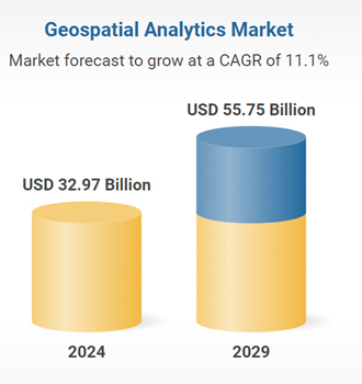
In 2022, Euroconsult (now part of NovaSpace) forecasted that the earth observation data and services market would be worth US$7.9 billion in 2031, with approximately US$5 billion of this being accounted for by services. Key sectors were: defense, natural resources, infrastructure and energy. Other analysts are significantly more bullish. Markets and Markets, for example, valued the geospatial analytics market at US$32.97 billion in 2024, growing to US$55.75 billion by 2029.
Middle East and Africa (MEA) Geospatial Trends
This is a region that is placing a high emphasis on infrastructure development, urbanization and resource management. For example, countries in the Gulf Cooperation Council (GCC) are investing heavily in smart city projects. It’s also a region with rich in oil and gas resources. Two segments that both rely heavily on the use of geospatial technology. Smart cities depend on it for urban planning and utility management, whilst the energy sector is a big user of advanced geospatial tools for exploration, management and monitoring.
In Saudi Arabia, advanced Earth Observation and Geospatial capabilities are very much a key part of the Kingdom’s Vision 2030. This, along with the requirements from the energy industry, is driving the provision and use of geospatial technologies. One example of a Vision 2030 project is NEOM. NEOM, is an ambitious US$500 billion infrastructure project, which includes “The Line,” a 170 kilometer-long linear city, with no cars, roads and zero emissions, which will rely heavily on geospatial technology and AI. Although behind schedule and facing funding difficulties, the project is still progressing.
Given this emphasis on geospatial technologies, it is no big surprise to learn that the Kingdom has recently significantly improved its ranking in the Geospatial Knowledge Infrastructure (GKI) Readiness Index. In 2022 it ranked 32nd in the world. Now, in 2025 it ranks 9th in the world, 1st in the Middle East and Arab World and 6th amongst the G20 countries.
Neo Space Group
Neo Space Group (NSG), a Public Investment Fund (PIF)-owned company, and Saudi Arabia’s leading commercial space services provider, is at the forefront of Saudi Arabia’s improved ranking in the GKI Index. It is the leading company in geospatial services and products in Saudi Arabia. In the middle of 2024, it acquired Taqnia ETS, a company with a strong ten-year track record in geospatial services and solutions including over 130 successful projects. Its expertise includes advanced services such as geospatial analysis, data management and visualization. Taqnia ETS has now been rebranded as NSG Geospatial Services.
Adding to its portfolio of geospatial service offerings, NSG is in the process of finalizing its acquisition of UP42 from Airbus. UP42 provides access to data and analytics from over 80 of the world’s leading geospatial companies. This extensive portfolio makes it easy for clients to source and manage data from multiple providers through one interface. When the acquisition is complete, UP42 will be merged into NSG Geospatial Services.
At the beginning of 2025 NSG also signed an MoU with Esri Global Inc., Esri’s ArcGIS is regarded as the world’s leading GIS mapping software. When signing the MoU, Martijn Blanken, CEO, NSG said, “This collaboration will focus on R&D initiatives that push the boundaries of geospatial technology, delivering groundbreaking solutions across various sectors”. The partnership will leverage EO and remote sensing data to develop specialist applications in agriculture, defense, security, environmental monitoring, urban planning and maritime amongst others.
Headquartered in Riyadh, and dominating the Saudi Geospatial Technology marketplace, NSG Geospatial Services is also a key player in the European marketplace. In Saudi 80% of its business is with the government which uses geospatial technologies for civil defense, border control and disaster preparedness. The other 20% is for monitoring critical infrastructure, agricultural technology and forestry. In Europe the balance is the total opposite, with government only accounting for 20% and commercial enterprises 80%.
Downstream Services
NSG Geospatial Services has partnerships with the major upstream providers, Maxar, Iceye and Pixxel for example, however, its expertise is currently focused on downstream services where it covers the entire value chain, from data acquisition through advanced analytics and ready-to-use data products to near-real-time geospatial intelligence. The entire process is vertically integrated, ensuring that not only the highest levels of security are in use at every level of the value chain, but also that NSG has total control over quality, accuracy and update frequency, all of which are crucial for sensitive projects and decision making.
It specializes in customized geospatial analysis and insights for demanding customers. Customers that, for example, work in national defense, urban development, environmental conservation,and infrastructure resilience. The highly specialized information and insights NSG delivers, means that its clients benefit from reduced risks and lower costs than those associated with traditional trial-and-error approaches.
NSG has an in-house map production facility and its facilities comply with 14 ISO standards, NSG continues to meet global best practices while supporting the economic growth of government and private organizations.
Customized Services
In common with many companies in the business, NSG Geospatial Services, use AI and ML tools to analyze the data, recognize patterns and deliver actionable insights. What sets the company apart is that in addition, it employs highly specialized local experts, to support and verify the results.
To make the results easy to visualize and comprehend, information is transformed into maps and when appropriate 3D and digital elevation models. NSG Geospatial Services also integrate data into custom built web and mobile portals and GIS applications and dashboards. If required it can also design, build and develop additional digital platforms to integrate with clients’ systems.
Additional services such as managing GIS centers, programs and projects can also be provided.
Off-the-Shelf Products
As well as providing customized solutions, NSG Geospatial Services, also has three product lines available on a subscription basis:
- Neo Maps, a multi-system map platform for Saudi Arabia, providing users with an ever-growing choice of features – currently 12.5 million - to monitor operations, access and analyze geospatial data, through an interactive digital map platform. Features include: 25 million 3D models of structures and landmarks; Over 300,000 kilometers of primary and secondary roads; Over 4,000 population centers (from small rural communities to major cities); and over 1 million “points of interest,” landmarks, government buildings, community sites etc.
- Neo Intelligence Cell (NIC), a specialized unit designed to gather, analyze and leverage commercial intelligence to enhance military and civil operations as well as strategic decision-making. It integrates earth observation with other sources of relevant data. Advanced AI-powered systems utilize this data to deliver near-real-time actionable insights and detailed analysis.
Neo Atlas, a vast array of national and global datasets, data layers and maps, built in NSG’s own Neo Data Factory. Sources include: satellite images, demographic information, environmental data, land cover etc. All these are continuously updated reflecting real-world changes. Neo Atlas also enables users to create specialized maps, conduct analyses and share insights using current and relevant data. To date NSG Geospatial Services (through its acquisition of Taqnia ETS) has delivered over 120 projects covering a wide range of industries for both government and commercial entities. With this experience, coupled with its extensive data resources and inhouse analytical expertise, going forward it is ideally placed to meet the needs of a vast range of clients. Only a year old, NSG is already a very impressive company, with powerful geospatial analysis capabilities and tools at its disposal. And it is continuing to forge ahead, developing new capabilities and new alliances. Its most recent alliance is with HawkEye 360. HawkEye 360’s satellites are uniquely able to identify and geolocate sources of radio frequencies, which can reveal information about previously unknown activities around the world. Abdulaziz Alfarraj, CEO, NSG Geospatial Services, commented: “Together, we aim to unlock innovative solutions that support decision-making and create strategic value across sectors. We’re optimistic about the opportunities this partnership brings toward a smarter, digitally driven future.”
NSG Geospatial Services is the number one source for geospatial information in Saudi Arabia and beyond, and the first choice for any organization or government entity looking for a forward looking, reliable and experience partner for geospatial services.
Related Article:
-----------------------
 Elisabeth Tweedie is Associate Editor of the Satellite Executive Briefing has over 20 years experience at the cutting edge of new communications entertainment technologies. She is the founder and President of Definitive Direction (www.definitivedirection.com), a consultancy that focuses on researching and evaluating the long-term potential for new ventures, initiating their development, and identifying and developing appropriate alliances. She can be reached at: etweedie@definitivedirection.com